
TILIW – A houseboat full of WW2 German POWs

Sam Stang_New Year’s eve_Der Erlkönig_hand laid stone_Kevin Massmann_Bob Brail_Centaur_James Miller_South Point_Rich Kuchem_Goat Island_a submerged barge_power line tower to the TNT plant_Weldon Spring Interpretive Center
Gentle readers, I want to tell you about a walk I took with Sam Stang (of Augusta Glass Studio) that led to a houseboat full of WW2 German POWs. Seems unlikely, doesn’t it? Well, I guess two old, bearded guys out walking on a cold and grey New Year’s Eve Day, 2025, in the Missouri River floodplain near Klondike is somewhat unlikely to start with. And when we encountered two young women, or possibly just girls, out there too…we knew this walk was going to be different.
Our fellow walkers, all bundled up against the cold, were down below us, closer to the river, but they waved and told us they had found some good flotsam and jetsam, and then they disappeared. Poof! I think they were just exercising good caution because Der Erlkönig is most often found in the sticks. But I must say that I truly admire anyone I encounter off the beaten path, especially 2 stalwart young ladies walking in the cold in rugged territory purely for the fun of it.
Sam and I wandered on until we found an easy route down the embankment to the river. We both remarked on how wicked the wind was on the sand bar. We continued upstream until we encountered what appeared to be a dry, sandy slough. Taking the path of least resistance, we traveled the slough, and it was huge. I think it could have hosted at least 30 beach volleyball games. The “volleyball courts” were crisscrossed with deer, coyote, and turkey tracks. Sam snapped a photo of me out there and immediately sent it to my phone. I deleted it soon thereafter, because I already know what an odd duck I am.
Anyway, it’s now August 2, 2026, and I just texted Sam to see if he still had that pic. He did, and now you do too.

When we drew close to the Labadie power plant, which was just across the river, we saw water in the slough, and like most creatures, our eyes were drawn to the water, not the bank on our right. Sam remarked on what he thought were beaver chewed trees along the depression. I expressed doubt because they were so evenly spaced and approximately all in a row. I thought it was man-made.
.

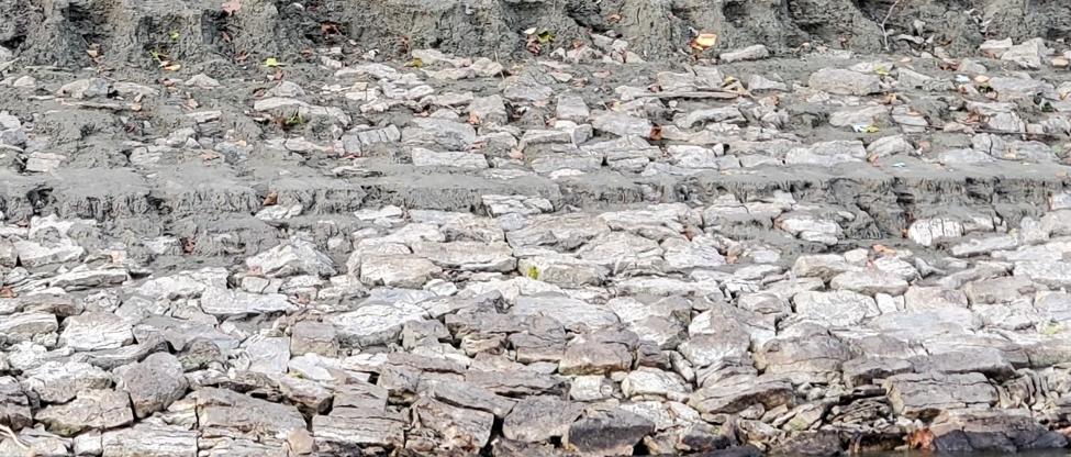
So, I started to look for evidence of additional human endeavor. It was there, alright, but much more orderly than what I had anticipated. At first, I just saw the riprap on the shoreline, but then I looked higher. Parallel with the bank were many courses of hand laid stone, not stacked like a wall, but embedded neatly into the slope. It went on for a few hundred feet.
Sam and I pondered all this and wondered if the presence of dock piers was connected to the fact that the Klondike silica plant was right behind us. Had there been a little dock to serve the quarry?

The next day, New Years Day, I asked Kevin Massmann, a genuine river rat (and I mean that in a most respectful way), what he knew about the hand laid stones. He told me that it was the work of WW2 German prisoners-of-war. He thought they were housed around St. Charles. Then I asked Keven how he had learned about the POWs, to which he replied, “I do not remember. I had that in my head a long time. I must have read about it somewhere though. Somebody hand-laid the rock on the riverbanks at some point. I know of other areas where it was done above and below Washington.”

I passed this information on to local historian, Bob Brail, and he replied that in his research he had never found anything about German prisoner camps in St. Charles County. However, he sent me a jpg of two pages from The Enemy Among Us by David Fiedler. (I’m on a waiting list now for the book from the St. Chas. County library.) The two pages are interesting enough that I am including a photo of it for your edification. The main thing to note is that there were prisoners quartered on a houseboat near Centaur and they were tasked with levee work from 2/1/45 to 5/25/45. Then they moved upriver to Washington, MO and remained there until September of that year.

Before I move on, here’s how David Fiedler’s book opens: During World War II, more than fifteen thousand German and Italian soldiers came to Missouri. This was no invasionary force; rather these were prisoners of war, part of a flood of almost a half-million men captured and sent to the United States, held here until the end of the war.
Life as a POW in the thirty camps scattered across Missouri was a surprisingly pleasant experience. The men ate well and were quartered under the same conditions as the Americans assigned to guard them, and the prisoners often enjoyed a great deal of freedom. The internees worked on local farms, often "guarded" only by a bored GI snoozing under a shade tree. They organized camp theater troupes, sports leagues, and orchestras, and some prisoners studied at the camp library for classes at the POW “university.”

Gentle readers, I guess some of you might wonder where Centaur is. In fact, it’s an unincorporated community that is officially part of Wildwood, MO. It’s located near the Missouri River. The area was first settled in 1797 bearing the name of St. Andrews. The actual community of Centaur came into being about 1885. Check out the Centaur mail wagon below:

And Bob Brail had more research to contribute. From the Washington Citizen, 5/18/45, there was a brief Sgt. Friday kind of report: “A group of German war prisoners were moved to South Point the latter part of last week where they will be stationed while working on the river. Prisoners have been employed on the river farther down stream for some time”.
And then they left…according to the Missourian:

There was also a Missourian editorial from the desk of editor and owner, James L. Miller. Here are some pertinent quotes, but below you can fully peruse page 6 of the May 17, 1945, issue.
“Last Sunday afternoon a few Washington people, mostly youngsters, went to South Point to see the Nazi prisoners of war, who are quartered on a boat there, and who are employed on the river. The visitors were not allowed to talk to the Nazis, nor were they allowed very close to them, but they did get close enough to see the Nazis lounging around on the deck of the boat, smoking cigarets (sic), and singing German songs. One of them even had a musical instrument! They appeared to be a very happy, contented, carefree and well fed group.”
The editorial proceeds to contrast the treatment American prisoners were receiving from the Germans: “In the meantime, our own boys are coming back from prisoner of war camps in Germany, and the tales they tell are not pleasant to hear.”

Bob Brail was kind enough to include one more Missourian article that offered a follow-up on a German POW named Hannes. I’ll let you enlarge it and read it yourself.

Sam and I were soon compelled to go back and look at the river maintenance again, and a week or two later I brought Bob Brail and Angela Stephens (Augusta Museum president) to see it. Now, I guess you think I have too much time on my hands. But I live on the same clock as you. The only possible difference is that I’m retired and full of curiosity. And I’m compelled to write and share.
The story could end here, but Kevin Massmann made a kind offer to take Angela and me on his fishing boat to see more German POW activity. However, the ups and downs of the river, and the ups and downs of life put our little tour off for a few months.
Finally, the date was set for July 29, so I went about soliciting life jackets for the adventure. I asked my Duke Road neighbor, Rich Kuchem, if I could borrow a couple. He said come by and get some. So, I did, but when I was at his home he asked me more about my planned outing with Kevin. I told him; he asked if he could tag along in his deluxe boat. Well, why would I say no?
Eventually, Kevin and Rich had a little talk, and it was decided that we’d all go on Rich’s much larger vessel. We (Kevin, Rich and Donna Kuchem, Angela and her grandson, Peyton, and I met at the Klondike ramp, and we were soon on the river.


.
In a few minutes we were looking at the Labadie plant, but we didn’t stop to see the embedded stones that had started this whole adventure…Kevin and Rich were already familiar with my “discovery”.

On the Franklin County side, but before Washington, Kevin pointed out another area of POW maintenance. We couldn’t get too close because Rich’s boat had a greater draw than a small fishing boat. But we snapped a few photos. Here’s one that indicates more order than mere dumping of stone. Admittedly, it wasn’t as convincing as what I had seen on New Year’s Eve Day, but I’ll let you be the judge.
We proceeded upstream and eventually passed under the Hwy. 47 bridge. This was the first time that I had floated under the new bridge. Of course, back in the 80s and 90s, I canoed under the old bridge several times with the likes of John LaPointe, Jimmy Reed, Sam and Pam White, Zia Gipson, Thad Brady, Franz Mayer, Dave Klaas, and others that I can’t recall just now.

Kevin guided us to another WW2 POW worksite on the Franklin County side, and then we looked at some ancient, decayed concrete slabs on the Warren County side. Kevin surmised the concrete was related to the POW work.

Shortly, we reached river mile marker 73, halfway between Washington and New Haven. We then turned around for home but slowed down enough to catch a photo of Goat Island which was once inhabited by goats, guinea hens, and the elusive Eric Struckhoff.

As we floated downstream past the Labadie plant, Kevin offered to show us what can still be seen of a sunken barge on the Franklin County side.

Before long we were back at the Klondike ramp, but instead of disembarking we extended our Big Muddy cruise downriver in search of popular sand bars on our side of the river. Some of them looked inviting, but more interesting were the ruins of a powerline on the St. Chas. County side of the river. Still standing were 4 bases, or piers, that supported overhead transmission lines coming from…well, I didn’t know.
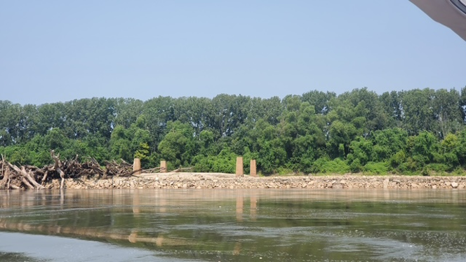
When I asked Kevin to clarify what I was seeing in this photo, he said, “I was told it was the base for the power line tower to the TNT plant in the 40s.” Then I went back and forth with Kevin regarding the source of the power heading to the Weldon Spring Ordnance plant. But it was the amazing Bob Brail, who came up with an answer even though he was initially stumped. Through his dogged research, he found the answer in the July 1941Union Electric Magazine. He sent me a link; hence, I learned this from an article written by Horace Lyon of the advertising department: “We are to serve the plant from Melrose (now Wildwood – my addition) substation now being constructed, and five miles of transmission line. Our facilities will be ready when needed. When in full operation, the plant will have an estimated 12,000-kilowatt load.”
But wait, there’s more…I felt a little guilty letting Bob Brail do all the heavy lifting. So, I contacted the Weldon Spring Interpretive Center. I spoke with Emily Crawford, and I asked her where the ordnance plant got its power from…or did I have it backwards? …did the plant produce its own electricity, and sell off its excess? Emily said she’d run the question by their “history buff interpreter”, Luke Scott.
And Luke Scott replied: We do have sources to confirm that power was generated at the WSOW and transferred across the Missouri River between the Ordnance Works and St. Louis County. One of our historic context documents says, “There were also two large power plants to serve the entire WSOW” and that the WSOW produced “600,000 pounds per day of steam,” likely to produce electricity. Tim Scherrer’s new book on the WSOW also says, “The structures [power houses] sat below rail lines that could drop coal into the building below” and “created high pressure steam used to turn pumps throughout the plant. Sixty-nine employees worked in power generation for the plant” (202-203). If I had to guess, I would think the WSOW produced most of its own electricity but perhaps also relied on the local grid for supplemental power.
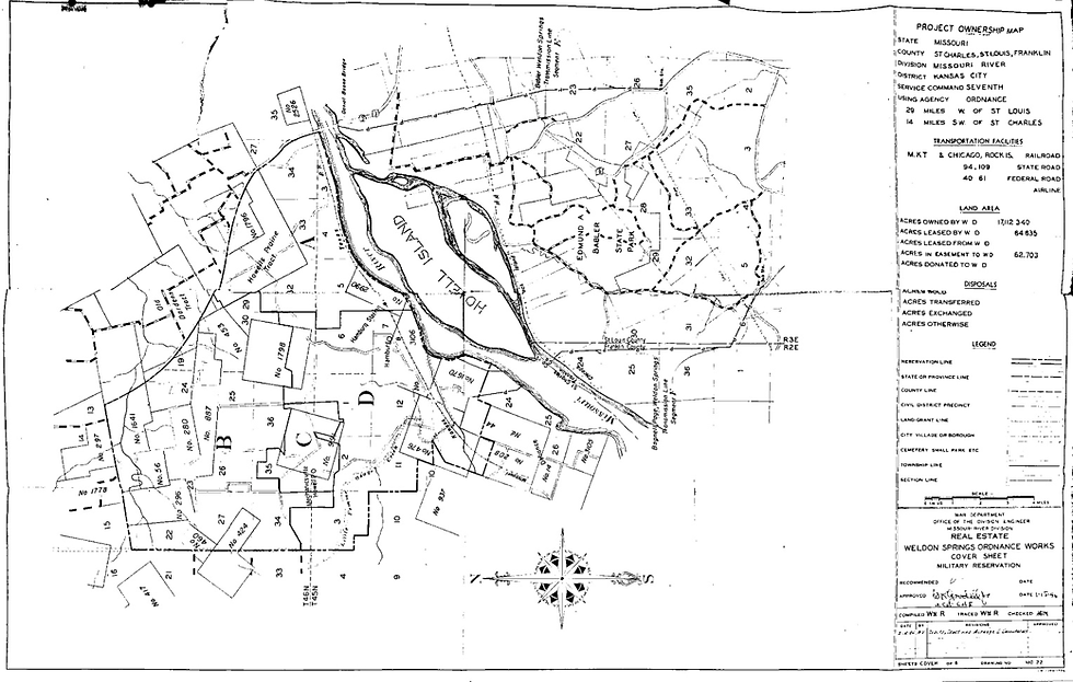
Regarding locations of power lines: If you look closely at the map in the jpg image, there are two transmission lines. One ran basically parallel to the St. Louis/Franklin County line and crossed just to the south of then-Howell Island. That appears to be roughly where Paul is referring to. There also appears to have been another transmission line that crossed by the Daniel Boone Bridge. Our pdf document shows detail on the Ordnance Works infrastructure, including the two transmission lines that came together at the “Power House” at the southern boundary of the Ordnance Works’ production area.
Rich Kuchem turned his craft around at the 50-mile marker and we headed upstream to Klondike. Had we gone much further, we might have found ourselves at Centaur where the houseboat full of German WW2 was once moored.

Soon, we were back at the floating dock at the Klondike park.

Today is October 7, 2026. Thank you for reading another of my lengthy stories.
Stay curious, gentle readers.
paulO


Comments